


Avanet app for iPhone and iPad
Developer: Mountain Hub, Inc.
First release : 18 Nov 2015
App size: 103.32 Mb
Avanet is the first global crowdsourced platform of mountain safety information. Join mountain professionals and recreationalists around the world who share real-time safety information to help everyone communicate and stay safe in the mountains. Avanet is all about contributing to and benefiting from our shared community, so hop on board and get involved! You can use Avanet everywhere - iPhone, iPad and online at https://avanet.avatech.com/.
RAPID OBSERVATIONS & RED FLAG ANALYTICS
Learn from crowdsourced geo-tagged observations of fellow mountain travelers and better inform your decision making.
Receive real-time local notifications of red flags and avoid dangerous situations before they happen.
See past photos, video, and audio information that gives you more knowledge before you head into new terrain.
Advance your mountain safety knowledge and help your local forecast center with real-time observations that can help improve public forecasts.
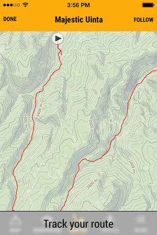
ROUTE PLANNING & TRACKING
Plan and track your route safely with the context of mountain safety information around you.
Save time and energy with automatic route planning tools and follow your route in the mountains.
Share planned routes and tracks with friends and colleagues to improve group communication and learning.
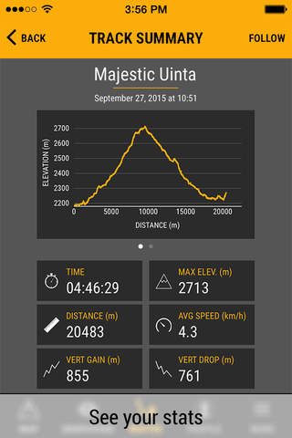
View real-time performance analytics so you can reflect and evaluate how you did versus your plan every time you go out.
MULTIPLE BASE LAYER MAPS
Select from a variety of mapping base layers including worldwide topo and aerial maps.
Use the best maps available spanning Mapbox, Caltopo, USGS, Austria Topo, LINZ New Zealand, and many more.
Cache maps and crowdsourced data for the cached region when you go into remote terrain.
TERRAIN ANALYSIS & VISUALIZATION
Visualize terrain in new and exciting ways.
Improve your understanding of terrain and how it affects your decision making.
NOTE: Continued use of GPS running in the background can dramatically decrease battery life. Avanet will automatically notify you at 20% battery life to help you preserve battery as the phone is an important safety device in the mountains. Avatech strongly recommends you bring an extra phone battery with you during your mountain travels.
SUPPORT
We love hearing from our users! We work with the most elite mountain professionals in the world, recreationalists, and general mountain enthusiasts in developing all of our technology. Avanet is a product of our entire community, so please share your feedback anytime and help us make Avanet even better for you!
Latest reviews of Avanet app for iPhone and iPad
Installation fail (iOS 9.2)!! Former installed version now seems to be incompatible- "update impossible"!
since last month, I cant see Avanet map on web site (desk top) what happening?
Getting better with every update!
The Avanet route-planning tool is gorgeous and extremely functional. I plan to use it every day I ride this year.
This app brings critical info I need in the mountains to the palm of my hand. The UI looks awesome, but there is not much data yet. Ill see if I can change that! :)